


Big Game & Game Bird Seasons
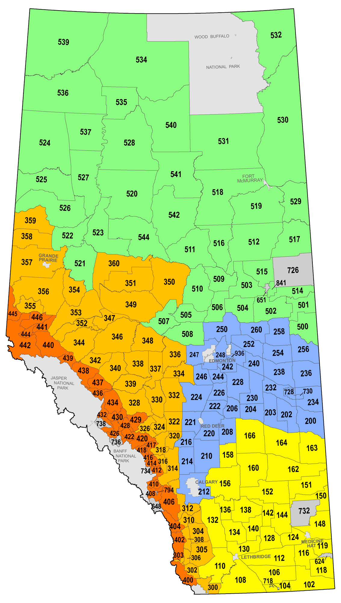
WMU Legal Land Descriptions & Maps
Click on the WMU of your choice to view the legal land description and map.
The following defines the month abbreviations used in the WMU links below:
A-August S-September O-October N-November D-December J-January F-February M-March Ap-April Ma-May Ju-June
WMU Descriptions
The WMU boundaries shown within this website are small-scale approximations of the actual units legally described in the Wildlife Regulation (AR 143/97) and subsequent amendments. The maps within this website are provided to help you identify the WMU in which you wish to hunt. It is your responsibility to know in which WMU you are hunting and the seasons, rules and regulations that govern hunting in that WMU. Text descriptions of the WMU boundaries may be either read within this website, at your nearest Fish and Wildlife Division office or through the Alberta King’s Printer website (https://www.alberta.ca/alberta-kings-printer.aspx) or purchased from The Alberta King’s Printer at the following address:
Alberta King’s Printer
10611 - 98 Avenue
Edmonton, AB T5K 2P7
Telephone: (780) 427-4952
NOTE: Maps can be found online at mywildalberta.ca/hunting/regulations/default.aspx.
MAPS
Maps providing information about access, topography and land ownership can be purchased at several locations throughout the province. Contact your local Map Dealer. Certain Government of Alberta maps, including WMUs, sanctuaries, useful for planning hunts, can be found at https://geospatial.alberta.ca/FWIMT_Pub/Viewer/?TermsOfUseRequired=true&Viewer=FWIMT_Pub.
Provincial and Federal Maps
Provincial and federal access and topographical maps are available from various private map dealers throughout the province.
County and Other Municipal Maps
Hunters are reminded to check with county and municipal offices for detailed maps showing land ownership status. These maps are available for a nominal fee and are useful for determining land status and ownership, which can help you obtain permission for access.
FEDERAL FIREARMS LEGISLATION
All hunters should be aware of federal laws surrounding the acquisition, possession, transportation and use of weapons and ammunition. For further information contact your local police service or the Canadian Firearms Centre at 1-800-731-4000 or visit the Centre’s website at rcmp-grc.gc.ca/en/firearms.