 |
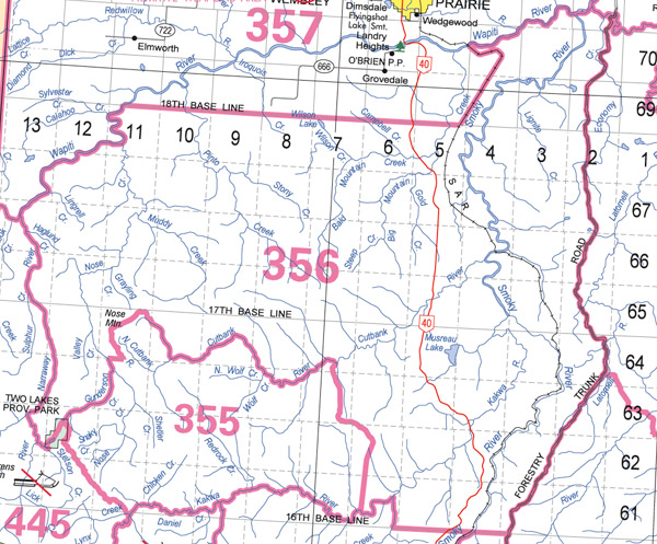
Cutbank Wildlife Management Unit (356)
Commencing at the confluence of the Narraway and Wapiti Rivers; thence northeasterly along the right bank of the Wapiti River to its intersection with the 18th baseline; thence easterly along the 18th baseline to the Canadian National Railway railway line; thence northeasterly along the Canadian National Railway railway line to the right bank of the Wapiti River; thence downstream along the right bank of the Wapiti River to the right bank of the Smoky River; thence along the right bank of the Smoky River to the right bank of the Simonette River; thence easterly along the right bank of the Simonette River to the Forestry Trunk Road; thence southerly along the Forestry Trunk Road to its intersection with the 16th baseline; thence westerly along the 16th baseline to the right bank of Prairie Creek; thence northerly along the right bank of Prairie Creek to the right bank of the Kakwa River; thence southwesterly along the right bank of the Kakwa River to the Grande Prairie‑Grande Cache powerline in section 8, township 61, range 6, west of the sixth meridian; thence northerly along the powerline to the Weyerhaeuser Long Lake Haul Road in the northeast quarter of section 21, township 62, range 6, west of the sixth meridian; thence northwesterly along the Weyerhaeuser Long Lake Haul Road to the right bank of the Cutbank River; thence upstream along the right bank of the Cutbank River to the right bank of the unnamed tributary in the southeast quarter of section 4, township 64, range 10, west of the sixth meridian; thence northwesterly along the right bank of the unnamed tributary to its intersection with the east boundary of township 64, range 11, west of the sixth meridian; thence northerly along the east boundary of township 64, range 11, west of the sixth meridian to its intersection with the Weyerhaeuser Nose Mountain Haul Road in the northeast quarter of section 25, township 64, range 11, west of the sixth meridian; thence westerly and southerly along the Weyerhaeuser Nose Mountain Haul Road to its intersection with the south boundary of township 64, range 11, west of the sixth meridian; thence westerly along the south boundary of township 64 to the right bank of Nose Creek; thence southerly along the right bank of Nose Creek to the right bank of Gunderson Creek; thence southwesterly along the right bank of Gunderson Creek to its intersection with an unnamed tributary in the southeast quarter of section 33, township 62, range 12, west of the sixth meridian; thence southwesterly along the unnamed tributary to the Torrens Forestry Lookout Tower Road locally known as Hat Mountain Road in the northwest quarter of section 21, township 62, range 12, west of the sixth meridian; thence northwesterly along the Torrens Forestry Lookout Tower Road to the road locally known as the Two Lakes Road; thence southwesterly along the Two Lakes Road to the right bank of Stetson Creek in township 62, range 12, west of the sixth meridian; thence southwesterly along the right bank of Stetson Creek to the right bank of the Torrens River; thence northwesterly along the right bank of the Torrens River to the right bank of the Narraway River; thence northerly along the right bank of the Narraway River to the point of commencement.