 |
Edmonton East Wildlife Management Unit (248)
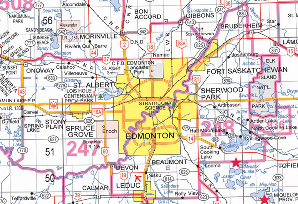
Commencing at the junction of the Sturgeon River and the North Saskatchewan River; thence downstream along the right bank of the North Saskatchewan River to range road 205; thence southerly on range road 205 to highway 15; thence easterly along highway 15 to range road 204, thence southerly on range road 204 to township road 550 along the northern boundary of township 54 to the northwest corner of Elk Island National Park; thence southerly along the western boundary of Elk Island National Park to the southwest corner of the Park; thence continuing southerly along range Road 210 (Strathcona County rural addressing system) to the Canadian National Railway (CNR) tracks at North Cooking Lake; thence southeasterly along the CNR tracks to township road 514; thence westerly and southerly along township road 514 until it turns southerly to become range road 203 in section 22, township 51, range 20, west of the fourth meridian; thence continuing southerly along range road 203 to township road 510 at the northern boundary of township 50, west of the fourth meridian; thence westerly along township road 510 to highway 21; thence southerly along highway 21 to the Airport Road at the northeast corner of section 11, township 50, range 23, west of the fourth meridian; thence continuing southerly along the east side of sections 2 and 11, township 50 and sections 26 and 35, township 49, range 23, west of the fourth meridian to secondary road 623; thence westerly along secondary road 623 to 50th Street in Leduc; thence southerly along 50th Street to highway 2A; thence northwesterly along highway 2A to highway 2; thence northerly along highway 2 to highway 39; thence westerly along highway 39 to highway 60; thence northerly along highway 60 to the North Saskatchewan River; thence