Click Here to view Map Legend
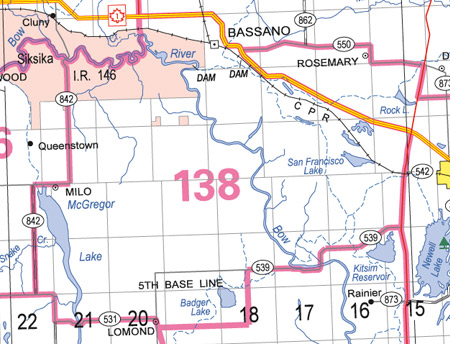
Majorville Wildlife Management Unit (138)
Commencing where secondary road 842 crosses the Bow River, near Cluny; thence downstream along the right bank of the Bow River to the ferry landing within the northwest quarter of section 24, township 21, range 20, west of the fourth meridian; thence easterly and northerly along an unnamed gravel road for approximately 3 miles to its junction with highway 1 (TransCanada); thence easterly along highway 1 to highway 36; thence southerly along highway 36 to secondary road 539; thence westerly and southerly along secondary road 539 across the Bow River; thence continuing westerly approximately 8 miles to range road 18‑3; thence southerly along range road 18‑3 to township road 16‑2; thence westerly along township road 16‑2 to the C.P.R. right‑of‑way; thence northwesterly along the C.P.R. right‑of‑way to secondary road 845 near Lomond; thence westerly on secondary road 845 to where it becomes secondary road 531; thence westerly on secondary road 531 to secondary road 842; thence northerly along secondary road 842 to secondary road 534; thence westerly on secondary road 534 approximately 2 miles to secondary road 842; thence northerly on secondary road 842 to secondary road 542; thence easterly on secondary road 542 approximately 4 miles to secondary road 842; thence northerly on secondary road 842 to the point of commencement.